

C2C Route Maps
C2C GPX files are available to download from AllTrails as below. Contact Kaye Cox if there are any issues, or if you would like the files emailed. (links coming soon)
Hike & Bike (25/78km)
Bike Only (103km)
Hike only (25km)
*no paper maps available
C2C’23
C2C Event Co-ordinator, Kaye Cox, was part of the team who created Cairngorm to Coast back in 2015 and was delighted to finally take part in 2023. If her video inspires you, follow the link below for more details and to sign up.
C2C’22
This Relive video shows you the 2022 route, highlighting the marshal checkpoints along the way. NB: the route has changed between Glenmore Lodge and Nethy Bridge and no longer finishes at Windswept Brewing – please follow the AllTrails link above for the most up-to-date route.
C2C’17: “The Year of Rain”
Thanks to Gavin Smith for this fantastic video of the C2C’17 front runners. It rained from beginning to end that year but, as this video shows, it didn’t take anything away from the participants’ enjoyment of the event! Inspired? Click on the link below for more information and sign up.
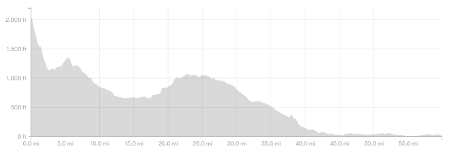
Elevation Profile
We’d like to say that Cairngorm to Coast is downhill all the way but, as this elevantion profile shows, there are a few hills here and there to catch you out!